
Can you hike in Zhangjiajie?
Yes. Most visitors ride the eco-buses, cable cars and the Bailong Elevator, so the walking trails are usually far quieter than the viewpoints. We plan hikes on trails that are open now: Golden Whip Stream (flat, about 6.5 km), Yaozizhai (reopened in September 2025), the Huangshizhai stone steps, the clifftop loops, Tianmen Mountain‘s summit walks and the Grand Canyon floor.
Some trails in Zhangjiajie close for repairs or bad weather. You are booking weeks or months ahead, so this page covers the trails we are happy to build a day around, with distances, times and what to bring, and we check each one again for your dates. For park gates and time slots, see our Zhangjiajie ticket rules page and the free English map of the park.
1. What hiking in Zhangjiajie is like
Zhangjiajie National Forest Park has three kinds of walking: flat valley trails, stone-step climbs, and clifftop loops once you are up. The park is large, and its clifftop areas are linked by eco-buses, so even keen hikers ride the bus between areas. When people say they hiked “without the cable car”, they still rode the eco-bus.
- An eco-bus ticket gives unlimited rides for the four days. The Bailong Elevator and the cable cars are paid per ride.
- The clifftop loops at Yuanjiajie, Yangjiajie and Tianzi Mountain are reached by bus or lift and then walked. They have railings, and most visitors walk them.
- For a real climb from the valley floor, we plan Huangshizhai and Yaozizhai, and, for strong hikers, Luancuan Slope up to Yuanjiajie.
2. The trails we recommend, at a glance
From easiest to hardest: Golden Whip Stream, the Ten-Mile Gallery walk, the clifftop loops, the Grand Canyon floor, Tianmen Mountain’s summit walks, the Huangshizhai steps and Yaozizhai. For strong hikers there is also Luancuan Slope. Distances come from park signs or official figures. Trails can close for repairs or weather, so we check each one again for your dates.
| Trail | From – to | Distance | Time | Terrain | Good for |
|---|---|---|---|---|---|
| Golden Whip Stream | South Gate (Oxygen Bar Square) to Shuiraosimen, one way | About 6.5 km | 2–3 hours | Flat path beside a stream | Almost everyone, including children |
| Ten-Mile Gallery on foot | The walkway beside the mini-train | The gorge is about 5 km long | A short walk | Flat or gently downhill | Almost everyone |
| Yuanjiajie clifftop loop | Mihun Platform, Hallelujah Mountain, First Bridge Under Heaven | — | 1–3 hours, depending on how many viewpoints | Walkways with railings | Almost everyone |
| Yangjiajie clifftop | Natural Great Wall; Wulong Village loop | — | Natural Great Wall is close to the bus stop; Wulong Village loop 1–1.5 hours | Narrow sections at Wulong Village | Great Wall for most people; Wulong Village for steady walkers |
| Grand Canyon floor (Line A) | Down the gully to the canyon floor, along the stream, boat to the exit | 3 km | About 3 hours | Steps down, then mostly shaded path; wet in places | Most people |
| Tianmen Mountain summit | East Line and West Line, meeting at Tianmen Temple | Ghost Valley plank road about 1.6 km | About 3–4 hours for both | Cliff walkways and steps | Anyone comfortable with heights |
| Huangshizhai steps | Front trail near the Golden Whip Stream entrance to the summit, and back the same way | About 3.2 km up; 4,588 steps | 1–2 hours up, plus the summit loop | Stone steps under trees | Steady walkers |
| Yaozizhai | South Gate side up to the summit loop, and back the same way | About 2.6 km up; 1,328 m summit loop | About 4 hours up and down | Steps and slopes, well signposted | Steady walkers who want quiet trails |
| Luancuan Slope (strong hikers) | Middle of Golden Whip Stream up to Yuanjiajie | About 2.3 km | About 1.5 hours up | Steep stone steps | Strong hikers |
3. Yaozizhai: a trail that reopened after almost ten years
Yaozizhai is on the South Gate side of Zhangjiajie National Forest Park, near Golden Whip Stream and Huangshizhai. It closed in early 2016 and reopened on 27 September 2025. From Oxygen Bar Square it is about 2.6 km and 1.5 hours up to the summit, where a 1,328 m loop takes about 1.5 hours. The park sign allows about 4 hours up and down.
Why it was closed, and what changed
It is named after one of its peaks, which is shaped like a sparrowhawk (yaozi). From above it is a long, narrow ridge with sheer cliffs on three sides, and it faces Huangshizhai and Yuanjiajie across the valley: three great sandstone ridges standing apart.
- In early 2016 the park closed Yaozizhai to visitors under Hunan’s rules for protecting the Wulingyuan World Natural Heritage Site, so the forest could recover.
- In 2025 the park repaired the old paths and viewing points, keeping the trail as a walking route with no lifts or buses.
- It reopened on 27 September 2025, World Tourism Day, with a first hill-climbing race on the same day.
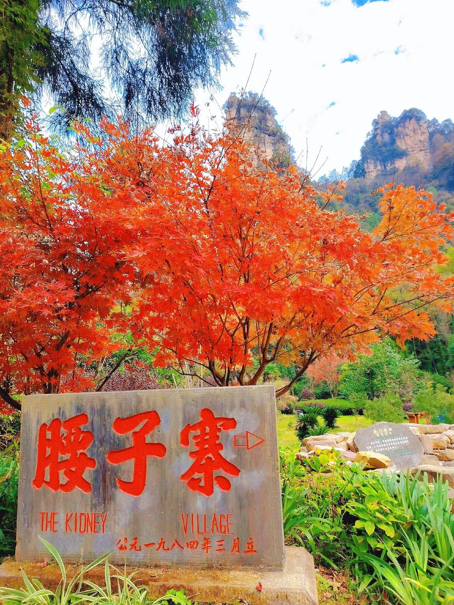
- The old stone marker near the trailhead still shows the earlier name, written with different Chinese characters that mean “kidney”: hence “The Kidney Village”.
What lives here
During the closure, park staff recorded Elliot’s pheasant, a nationally protected Class I species in China, as well as Temminck’s tragopan, the Asian barred owlet, tufted deer and leopard cats. Troops of wild macaques live along the trail. The forest includes dove trees (Davidia) and Chinese yews, both protected at the highest national level.
What you see on the way
- The lower trail: a shaded path beside a stream, then stone steps past named rocks such as Feiyingbao, Xiangzhu Peak, Liubin Rock and Jade Rabbit Gazing at the Moon.
- Baiying Valley: a few wooden buildings, a trail map and the fork where the path splits: left to the summit, right down to Golden Whip Stream.
- The summit: the Zhidian Jiangshan and Jingguan Fengyun viewpoints, with open views over the sandstone peaks, down to Golden Whip Stream and across to Huangshizhai and Yuanjiajie. The highest point is about 1,050 m. Other named sights include Golden Snail Asking Heaven, Eagle’s Beak and Javelin Peak.
- The summit teahouse: an eagle sculpture, a few bamboo chairs and one of the trail’s two toilets.
The route, stage by stage
| Stage | What to expect | Time |
|---|---|---|
| South Gate to the trailhead | Walk towards Oxygen Bar Square; the trailhead is by the toilets, with a signpost | A few minutes |
| Trailhead to Baiying Valley | Stream-side path, then stone steps; toilets at the Baiying Valley duty room | About 1 hour |
| Baiying Valley to the summit | Take the left fork; steps up to the ridge | About 30 minutes |
| Summit loops | A short loop of 5–10 minutes and a 1,328 m loop past the viewpoints | About 1.5 hours |
| Back down the same way | Return to Baiying Valley and down the South Gate side | About 1–1.5 hours |
The park sign gives about 2.6 km and 1.5 hours from the trailhead to the summit, and about 4 hours up and down. Allow 5–6 hours gate to gate if you stop for photos and lunch.
Ways to combine it
- South Gate in and out (our usual plan). Up and down the South Gate side. The paths are paved, the steps are not steep, and this is the gentler side.
- Yaozizhai, then Golden Whip Stream. Up from the South Gate, then at Baiying Valley take the right fork down to Golden Whip Stream. Park signs give about 2 km and an hour down; from there, walk the stream to Shuiraosimen and take the eco-bus to the East Gate. A full day.
- Up from Golden Whip Stream (strong hikers only). The Golden Whip side is a steep, straight climb, with moss on the steps. Go up this way only if you are fit, and come down on the South Gate side.
In rain, keep to the South Gate side both ways: the steps down to Golden Whip Stream are mossy and slippery.
What to bring and know
- Water and food for the whole walk. Nothing is sold on the trail; buy what you need at the small shop near the South Gate trailhead.
- Toilets: use the ones at Oxygen Bar Square before you start. On the trail there are only two, at the Baiying Valley duty room and the summit teahouse, and the summit one is basic.
- Few places to sit. Apart from the teahouse, there are no benches.
- Macaques. Keep food in your bag and plastic bags out of sight. Do not feed them, do not stare, and keep walking.
- An early start. Parts of the forest are dark, so start in the morning.
- No smoking and no flames. It is a protected forest, and fire-safety announcements play at the summit viewpoints.
- Walking poles help on the steps, especially going down.
Stay inside the railings at the viewpoints.
Tickets and getting there
- Yaozizhai is included in the four-day Zhangjiajie National Forest Park ticket. You book the South Gate and a time slot as for any park day; there is nothing extra to buy or book.
- The South Gate is on the other side of Wulingyuan from the East Gate area. On a private tour we drive you there.
Who it suits
Steady walkers who would rather spend a day on a quiet trail than in queues. Hikers report meeting only a handful of people, even on national holidays. If you have knee trouble, avoid the Golden Whip side.
4. The other trails, in more detail
Golden Whip Stream
Golden Whip Stream is a flat trail of about 6.5 km beside a clear mountain stream, from Oxygen Bar Square at the South Gate to Shuiraosimen. It takes 2–3 hours, is shaded most of the way and suits almost everyone. From Shuiraosimen you ride the eco-bus out of the park.
- Scenes from the television series Journey to the West were filmed along the stream.
- Short on time? Walk in from the South Gate for a short way and turn back: about half an hour to 40 minutes there and back.
Huangshizhai
The Huangshizhai front trail starts near the Golden Whip Stream entrance at Oxygen Bar Square, not at the cable car station. It is about 3.2 km and 4,588 stone steps, 1–2 hours up to the Six Wonders Pavilion on the summit. Come back the same way or take the cable car one way; the back trail is closed.
- The 4,588 is the park’s own count, from the sign at the top.
- On the summit there is a long loop of about 2.5 km and a short loop of about 1.2 km.
- Wild macaques are common on Huangshizhai. Keep food packed away.
Luancuan Slope: walking up to Yuanjiajie (for strong hikers)
Luancuan Slope is a steep stone-step trail of about 2.3 km from the middle of Golden Whip Stream up to Yuanjiajie, the walking alternative to the Bailong Elevator. It is open as of September 2026. Allow about 1.5 hours up; it is hard on the knees coming down. It has closed at times in the past, so we confirm it is open before your trip.
Tianzi Mountain
- From the Tianzi Mountain bus stops, He Long Park, Imperial Writing Brush Peak and Fairies Presenting Flowers are short, easy walks.
- For strong hikers: two trails go down from Tianzi Mountain on foot, one via Wolong Ridge to the Ten-Mile Gallery (about 2–3 hours down) and one via South Heavenly Gate to the road at Sansuo (about 1–1.5 hours down). Both are open as of September 2026 and both are drawn on the park’s own trail map. They are long, with many steps, and slippery after rain. We confirm both again before your trip.
Tianmen Mountain
There is no official hiking trail up Tianmen Mountain from the bottom; the way up is by cableway, park bus and escalators. What you can walk is the 999 steps up to Tianmen Cave, with a paid escalator as the alternative, and the East Line and West Line on the summit. The two lines start at the summit hub and meet at Tianmen Temple, so you can walk both as one loop: allow about 3–4 hours for both. The whole visit on Tianmen’s Line A ticket route, including getting up and down, takes about 4–6 hours.
- Along the summit walks are the Ghost Valley plank road, about 1.6 km, and the Coiling Dragon Cliff glass walkway, 100 m.
- The East Line glass skywalk has reopened; all three glass skywalks were open when we checked on 1 October 2026. Part of the East Line may be closed on your date; we check before you go.
- For the whole visit, see how long Tianmen Mountain takes and our Tianmen Mountain English map.
Grand Canyon
The Zhangjiajie Grand Canyon is a separate scenic area with its own ticket. For a walk there, choose Line A: down a narrow gully to the canyon floor, along the stream, and out by boat. The park lists Line A at 3 km and about 3 hours, and stops ticket checks at 4 pm. Line B adds the Glass Bridge, about 3.5 km and 3.5 hours.
- The canyon floor is mostly shaded; a few stretches are wet and slippery.
- The Glass Bridge needs a booking in advance with a time slot. See our Glass Bridge guide.
Want more walking and fewer queues? Tell us how much you like to hike and how many days you have, and we will plan each day on trails that are open.
5. Before you go
Book your park gate and time slot in advance; wear shoes with grip; carry water and food; keep food away from the monkeys; and plan to be out of the park before dark. Lift and cable car queues build up at busy times, so if you plan to ride down, do not leave it until late in the afternoon.
- Every park entry is booked for a gate and a time slot. At the East Gate your ticket is Line A (Tianzi cable car up, Bailong Elevator down) or Line B (the reverse), and changing it at the gate is often not possible. The South Gate is where the Golden Whip Stream, Huangshizhai and Yaozizhai trails start; if your East Gate slot is full, it is worth checking the South Gate.
- Ordinary rain does not stop the park’s transport, but wet stone steps are slippery, and moss grows on the quieter trails.
- Food and drink on the mountains is limited and costs more. On Yaozizhai, bring everything you need.
- Every ticket gate has luggage storage.
6. Trails we do not plan around
Some online “no cable car” itineraries use the back trail down from Huangshizhai or the climb up to Yangjiajie from below. The Huangshizhai back trail is closed, and the Yangjiajie climb has been reported closed or gated at different times in 2026. You are booking weeks or months ahead, so we do not build a day around them. We never plan trails that are fenced off.
Walk the quiet side of Zhangjiajie
Much of Zhangjiajie’s scenery lies a few hundred metres beyond the bus stops and viewing platforms. Tell us how much you want to walk, how many days you have and who is coming with you. We will plan each day on trails that are open: which gate, which time slot, which trail and where the bus picks you up.
For the park as a whole, see our Zhangjiajie National Forest Park guide and our private tours.
Plan your trip with us, or send us your dates on WhatsApp.
FAQ
Can you hike in Zhangjiajie?
Yes. Most visitors ride the eco-buses, cable cars and the Bailong Elevator, so the walking trails are usually far quieter than the viewpoints. We plan hikes on trails that are open now: Golden Whip Stream, Yaozizhai, the Huangshizhai stone steps, the clifftop loops, Tianmen Mountain’s summit walks and the Grand Canyon floor.
Which is the easiest hike in Zhangjiajie?
Golden Whip Stream. It is a flat trail of about 6.5 km beside a stream, from Oxygen Bar Square at the South Gate to Shuiraosimen, and takes 2–3 hours. It is shaded most of the way and suits children and most older travellers.
What is Yaozizhai and how do you hike it?
Yaozizhai is a trail on the South Gate side of Zhangjiajie National Forest Park. It closed in early 2016 and reopened on 27 September 2025. From Oxygen Bar Square it is about 2.6 km and 1.5 hours up to the summit, where a 1,328 m loop takes about 1.5 hours. It is included in the four-day park ticket.
Can you walk up Huangshizhai without the cable car?
Yes. The front trail starts near the Golden Whip Stream entrance at Oxygen Bar Square, not at the cable car station. It is about 3.2 km and 4,588 stone steps, 1–2 hours up to the summit. Come back the same way or take the cable car one way; the back trail is closed.
Can you hike up Tianmen Mountain?
There is no official trail up from the bottom; the way up is by cableway, park bus and escalators. You can walk the 999 steps up to Tianmen Cave, or take a paid escalator, and walk the East Line and West Line on the summit, about 3–4 hours for both. Part of the East Line may be closed for maintenance; we check before you go.
How long is the Grand Canyon hike in Zhangjiajie?
Line A, the canyon-floor walk, is 3 km and takes about 3 hours: down a gully, along the stream, and out by boat. Line B adds the Glass Bridge and is about 3.5 km and 3.5 hours. Line A ticket checks stop at 4 pm.
Sources and data notes
Reviewed in September 2026. We compared park and local-government notices, the Grand Canyon’s official route information, the park’s own trail signs, our own team’s experience in the park, and hikers’ trip reports from September 2025 to September 2026. Distances are those shown on park signs or published officially; times are typical walking times without long stops. Trails can close for repairs or weather; we check each one again for your travel dates.